Post by timbo on Apr 20, 2016 10:17:33 GMT
So there are 2 versions of this, a shorter 15 mile loop which is pretty much ridable from spring onwards and a longer, tougher 30 mile loop, which is one for summer. I spent ages exploring the moors and this puts together the most fun bits into a relatively easy/quick ride, suits an evening ride...
Fitnessometer: 6.5/10 (only really 1 bad climb)
Deathometer: 7.5/10 (goaw trail)
Getoffmylandometer: 1.5/10 (mostly bridleway)
Lostometer: 4/10 (id print this off and take note of the turns)

www.strava.com/activities/539477768
So we're starting from the Lion Inn on blakey ridge, really nice pub in the middle of nowhere (http://www.lionblakey.co.uk/ - YO62 7LQ), big car park, park on the far left so not to annoy the owners.
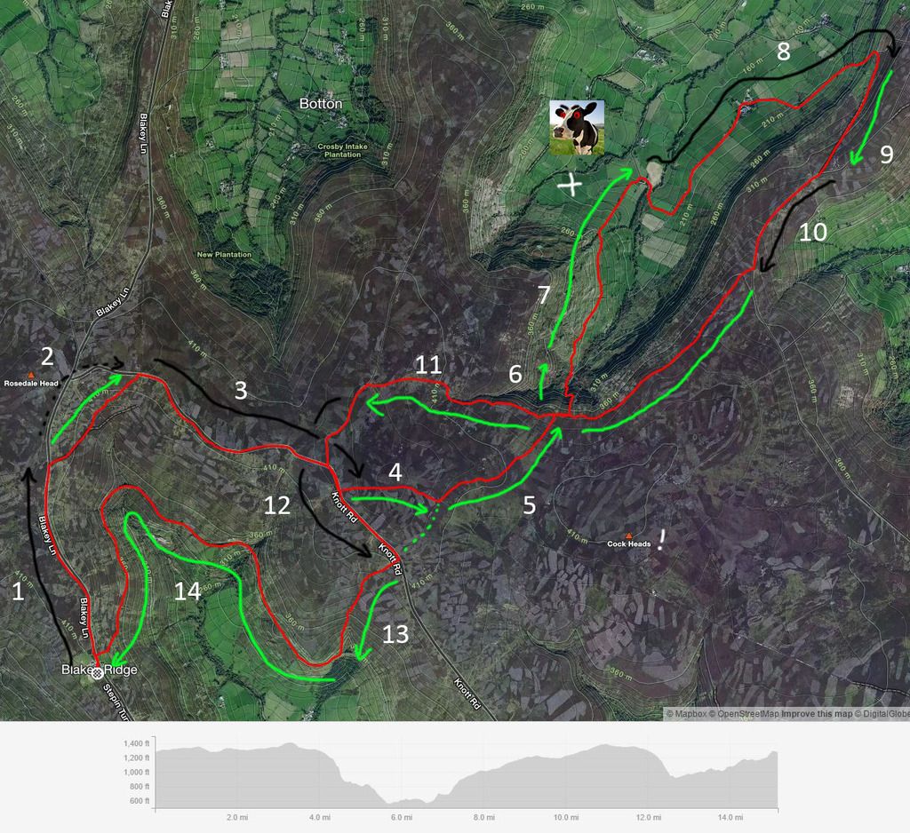
1: Road sections are in black, offroad in green, head up the road for a bit, be aware this is an awesome road, top gear and loads of mags shoot on it regularly, its wide enough but try not to get splattered.
2: Turn off the road at this point, i think its marked as a footpath, its one of the few sections that arent bridleways, fun little bit of moorland singletrack that cuts off the corner of the road, bit boggy when i rode it last week, but still rideable. If you're soft you can just follow the road round and skip this bit. Entrance is here: www.google.co.uk/maps/@54.4025447,-0.9613378,3a,43.5y,36.15h,76.26t/data=!3m6!1e1!3m4!1sT-EwBQSkMqgc1jXx4HKmGQ!2e0!7i13312!8i6656!6m1!1e1
3: back on the road for 4-5mins, bimble along there past the 2 junctions on your left, until you see this rocky singletrack going up the hill...
www.google.co.uk/maps/@54.4005462,-0.9266724,3a,84.9y,70.52h,63.79t/data=!3m6!1e1!3m4!1s2DLnaAJgpQQlhEHdWcKjjA!2e0!7i13312!8i6656!6m1!1e1
4: This takes you over the top, its rockier than it looks and a cool little climb, mind your mech. The far side of the hill is a very peaty however, can be boggy in the wet.
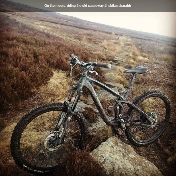
5: The old causeway thing, ive no idea what this is, but it looks pretty ancient and is basically an old 'paved' narrow path running across the moor. Its quite fun to ride, quite technical and you need to pay attention. If theres any doubt that section 3 will be ridable then you can head along the road a bit further and pic this up and do the full length, shown in dotted line.

Despite the path running for a mile or so, the end of this turns into a year round boggy bit, stay to all the way over to the right and you can ride through this, its all gently sloping, i made it through easy enough so so should you...
6: Short but scary descent 'GOAW factor 5/6' (ie, get off and walk). You'll come off the path onto a fireroad, turn right, roll downhill for a few seconds and you'll see a small pyramid of stones on the left, pick up the little trail just behind this. Its kind of like a natural staircase that snakes down the hill, if you've got a bash guard, you'll be making full use of it. Stay in a low gear, you wont be pedalling, after a few corners the trail turns back on its self and crosses a stream and up a short sharp climb. If you're a real man you'll try and ride/trials your way across the stream.
7: Cruise down into the valley, just follow the path along some grassy singletrack. You cross some fields towards the end, the last one before the road has killer cows in, be careful.
8: head right along the road for a mile or two and up a gentle climb
9: after you've got up the slightly less gentle gradient of that climb, theres a fireroad heading off right, take that past the cottage and the barky dog (hes cool)
10: short road section, ride along to here: www.google.co.uk/maps/@54.4160448,-0.8770843,3a,75y,229.86h,72.09t/data=!3m6!1e1!3m4!1s6BmHwsWOk8QSZL58NzwGMw!2e0!7i13312!8i6656!6m1!1e1
11: back on the fireroad, follow that back past the goaw trail, all teh way along to the road.
12: turn left on the road, next left again, we've been here before...
13: keep an eye out for the little wooden sign for rosedale here: www.google.co.uk/maps/@54.3957284,-0.9195159,3a,90y,211.35h,74.38t/data=!3m6!1e1!3m4!1sXx-wPZlp4Q9lhHqS8PVrWg!2e0!7i13312!8i6656!6m1!1e1
follow this down, its a great bit of singletrack if you know exactly what line to be on, but its very easy to get on the wrong one, not as in lost, but on a bit that just randomly stops. as a rule stay to the right for the first half and then swap over to the left. Watch out for random quite deep holes. you'll enjoy this more hte second time...
14: down onto the old railway line, which sounds dull as hell, but really isnt, theres some cracking singletrack round it and at least 1 climb that you probably wont make it to the top of. Follow that round stopping for various obvious photo opportunities, just when you're below the lion inn theres a short sharp climb back up to the carpark.
15: beer/food.
Ill update this with the longer one at some point
Fitnessometer: 6.5/10 (only really 1 bad climb)
Deathometer: 7.5/10 (goaw trail)
Getoffmylandometer: 1.5/10 (mostly bridleway)
Lostometer: 4/10 (id print this off and take note of the turns)

www.strava.com/activities/539477768
So we're starting from the Lion Inn on blakey ridge, really nice pub in the middle of nowhere (http://www.lionblakey.co.uk/ - YO62 7LQ), big car park, park on the far left so not to annoy the owners.
1: Road sections are in black, offroad in green, head up the road for a bit, be aware this is an awesome road, top gear and loads of mags shoot on it regularly, its wide enough but try not to get splattered.
2: Turn off the road at this point, i think its marked as a footpath, its one of the few sections that arent bridleways, fun little bit of moorland singletrack that cuts off the corner of the road, bit boggy when i rode it last week, but still rideable. If you're soft you can just follow the road round and skip this bit. Entrance is here: www.google.co.uk/maps/@54.4025447,-0.9613378,3a,43.5y,36.15h,76.26t/data=!3m6!1e1!3m4!1sT-EwBQSkMqgc1jXx4HKmGQ!2e0!7i13312!8i6656!6m1!1e1
3: back on the road for 4-5mins, bimble along there past the 2 junctions on your left, until you see this rocky singletrack going up the hill...
www.google.co.uk/maps/@54.4005462,-0.9266724,3a,84.9y,70.52h,63.79t/data=!3m6!1e1!3m4!1s2DLnaAJgpQQlhEHdWcKjjA!2e0!7i13312!8i6656!6m1!1e1
4: This takes you over the top, its rockier than it looks and a cool little climb, mind your mech. The far side of the hill is a very peaty however, can be boggy in the wet.
5: The old causeway thing, ive no idea what this is, but it looks pretty ancient and is basically an old 'paved' narrow path running across the moor. Its quite fun to ride, quite technical and you need to pay attention. If theres any doubt that section 3 will be ridable then you can head along the road a bit further and pic this up and do the full length, shown in dotted line.

Despite the path running for a mile or so, the end of this turns into a year round boggy bit, stay to all the way over to the right and you can ride through this, its all gently sloping, i made it through easy enough so so should you...
6: Short but scary descent 'GOAW factor 5/6' (ie, get off and walk). You'll come off the path onto a fireroad, turn right, roll downhill for a few seconds and you'll see a small pyramid of stones on the left, pick up the little trail just behind this. Its kind of like a natural staircase that snakes down the hill, if you've got a bash guard, you'll be making full use of it. Stay in a low gear, you wont be pedalling, after a few corners the trail turns back on its self and crosses a stream and up a short sharp climb. If you're a real man you'll try and ride/trials your way across the stream.
7: Cruise down into the valley, just follow the path along some grassy singletrack. You cross some fields towards the end, the last one before the road has killer cows in, be careful.
8: head right along the road for a mile or two and up a gentle climb
9: after you've got up the slightly less gentle gradient of that climb, theres a fireroad heading off right, take that past the cottage and the barky dog (hes cool)
10: short road section, ride along to here: www.google.co.uk/maps/@54.4160448,-0.8770843,3a,75y,229.86h,72.09t/data=!3m6!1e1!3m4!1s6BmHwsWOk8QSZL58NzwGMw!2e0!7i13312!8i6656!6m1!1e1
11: back on the fireroad, follow that back past the goaw trail, all teh way along to the road.
12: turn left on the road, next left again, we've been here before...
13: keep an eye out for the little wooden sign for rosedale here: www.google.co.uk/maps/@54.3957284,-0.9195159,3a,90y,211.35h,74.38t/data=!3m6!1e1!3m4!1sXx-wPZlp4Q9lhHqS8PVrWg!2e0!7i13312!8i6656!6m1!1e1
follow this down, its a great bit of singletrack if you know exactly what line to be on, but its very easy to get on the wrong one, not as in lost, but on a bit that just randomly stops. as a rule stay to the right for the first half and then swap over to the left. Watch out for random quite deep holes. you'll enjoy this more hte second time...
14: down onto the old railway line, which sounds dull as hell, but really isnt, theres some cracking singletrack round it and at least 1 climb that you probably wont make it to the top of. Follow that round stopping for various obvious photo opportunities, just when you're below the lion inn theres a short sharp climb back up to the carpark.
15: beer/food.
Ill update this with the longer one at some point


